
Haz una donación
Mapa topográfico Gackenbach
Haga clic en el mapa para ver la altitud.
Haz una donación
Gackenbach
Die katholische Pfarrkirche St. Bartholomäus und Sebastian in Kirchähr besteht mindestens seit 1200. Bis zur Fertigstellung der neuen Pfarrkirche in Gackenbach im Jahre 1884 war sie Sitz der Pfarrei Kirchähr. Jetzt hat diese Funktion die Gackenbacher Kirche übernommen und ist als beherrschendes Wahrzeichen des Dorfes weit über die Höhen des Buchfinkenlandes hinaus zu sehen. Die Pfarrkirche wurde innen zu großen Teilen mit Zierrat der alten romanischen Kirche in Kirchähr ausgestattet. Sehenswert ist u. a. das Flügelretabel, das aus der Zeit um 1480 stammt.
Haz una donación
Acerca de este mapa
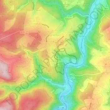
Nombre: Mapa topográfico Gackenbach, altitud, relieve.
Altitud media: 282 m
Altitud mínima: 135 m
Altitud máxima: 423 m
Haz una donación
Otros mapas topográficos
Haga clic en un mapa para ver su topografía, su altitud y su relieve.
Haz una donación
Haz una donación
Haz una donación
Zinhain
Deutschland > Rheinland-Pfalz > Westerwaldkreis > Bad Marienberg (Westerwald)
Die Ortschaft liegt etwa zwei Kilometer westlich des Stadtzentrums von Bad Marienberg in Hanglage über dem Tal der südlich fließenden Nister auf einer Höhe von durchschnittlich circa 480 m ü. NHN und steigt nach Norden hin bis auf etwa 550 m ü. NHN auf der „Zinhainer Höhe“ an.
Altitud media: 438 m
Haz una donación
Marienbad
Deutschland > Rheinland-Pfalz > Westerwaldkreis > Bad Marienberg (Westerwald) > Zinhain
Altitud media: 450 m
Haz una donación
Fuchskaute
Deutschland > Rheinland-Pfalz > Westerwaldkreis > Willingen
Die Fuchskaute hat zwei etwa 650 m voneinander entfernte Kuppen – mit Höhen in Meter (m) über Normalhöhennull (NHN): die auch Alteberg genannte Nordkuppe (656,4 m) und die Südkuppe (657,3 m), wobei sich letztere in zwei rund 175 m auseinander liegende Anhöhen aufteilt, nämlich in die Nordanhöhe (657,3…
Altitud media: 609 m
Haz una donación
Steinefrenz Bahnhof
Deutschland > Rheinland-Pfalz > Westerwaldkreis > Steinefrenz
Altitud media: 270 m
Eichenstruth
Deutschland > Rheinland-Pfalz > Westerwaldkreis > Bad Marienberg (Westerwald)
Altitud media: 483 m