
Mapa topográfico Wolfstein
Mapa interactivo
Haga clic en el mapa para ver la altitud.
Acerca de este mapa
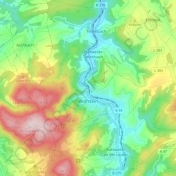
Nombre: Mapa topográfico Wolfstein, altitud, relieve.
Altitud media: 327 m
Altitud mínima: 178 m
Altitud máxima: 568 m
Durch Wolfstein führt die Bundesstraße 270. Die Umgehungsstraße der B 270 wurde am 17. November 2006 nach knapp fünfjähriger Bauzeit für den Verkehr freigegeben. Durch den Stadtteil Roßbach verläuft zudem die Kreisstraße 48. Die Stadt selbst ist über die Buslinie 274 und 275 des Verkehrsverbundes Rhein-Neckar an das Nahverkehrsnetz angebunden, die sie beide mit der Kreisstadt Kusel verbinden. Seit 2011 führt der circa 100 Kilometer lange Pfälzer Höhenweg von Winnweiler über Rockenhausen nach Wolfstein. Außerdem war die Stadt Station des Westpfalz-Wanderweges.
Otros mapas topográficos
Haga clic en un mapa para ver su topografía, su altitud y su relieve.
Kappeln
Deutschland > Rheinland-Pfalz > Landkreis Kusel
Kappeln, Lauterecken-Wolfstein, Landkreis Kusel, Rheinland-Pfalz, Deutschland
Altitud media: 293 m
Kreimbach-Kaulbach
Deutschland > Rheinland-Pfalz > Landkreis Kusel
Kreimbach-Kaulbach, Lauterecken-Wolfstein, Landkreis Kusel, Rheinland-Pfalz, 67757, Deutschland
Altitud media: 304 m
Jettenbach
Deutschland > Rheinland-Pfalz > Landkreis Kusel
Jettenbach, Lauterecken-Wolfstein, Landkreis Kusel, Rheinland-Pfalz, Deutschland
Altitud media: 376 m
66901
Deutschland > Rheinland-Pfalz > Landkreis Kusel > Schönenberg-Kübelberg > Kübelberg
66901, Kübelberg, Schönenberg-Kübelberg, Oberes Glantal, Landkreis Kusel, Rheinland-Pfalz, Deutschland
Altitud media: 253 m
66887
Deutschland > Rheinland-Pfalz > Landkreis Kusel > Elzweiler
66887, Elzweiler, Kusel-Altenglan, Landkreis Kusel, Rheinland-Pfalz, Deutschland
Altitud media: 379 m
Frohnhofen
Deutschland > Rheinland-Pfalz > Landkreis Kusel
Frohnhofen, Oberes Glantal, Landkreis Kusel, Rheinland-Pfalz, Deutschland
Altitud media: 372 m
Schönenberg
Deutschland > Rheinland-Pfalz > Landkreis Kusel > Schönenberg-Kübelberg
Schönenberg, Schönenberg-Kübelberg, Oberes Glantal, Landkreis Kusel, Rheinland-Pfalz, 66901, Deutschland
Altitud media: 266 m
Körborn
Deutschland > Rheinland-Pfalz > Landkreis Kusel
Körborn, Kusel-Altenglan, Landkreis Kusel, Rheinland-Pfalz, Deutschland
Altitud media: 383 m
Ginsweiler
Deutschland > Rheinland-Pfalz > Landkreis Kusel
Ginsweiler, Lauterecken-Wolfstein, Landkreis Kusel, Rheinland-Pfalz, Deutschland
Altitud media: 279 m
Grumbach
Deutschland > Rheinland-Pfalz > Landkreis Kusel
Grumbach, Lauterecken-Wolfstein, Landkreis Kusel, Rheinland-Pfalz, 67745, Deutschland
Altitud media: 282 m
Reipoltskirchen
Deutschland > Rheinland-Pfalz > Landkreis Kusel
Reipoltskirchen, Lauterecken-Wolfstein, Landkreis Kusel, Rheinland-Pfalz, Deutschland
Altitud media: 296 m
Hinzweiler
Deutschland > Rheinland-Pfalz > Landkreis Kusel
Hinzweiler, Lauterecken-Wolfstein, Landkreis Kusel, Rheinland-Pfalz, 67756, Deutschland
Altitud media: 299 m
Einöllen
Deutschland > Rheinland-Pfalz > Landkreis Kusel
Einöllen, Lauterecken-Wolfstein, Landkreis Kusel, Rheinland-Pfalz, 67753, Deutschland
Altitud media: 323 m
Herren-Sulzbach
Deutschland > Rheinland-Pfalz > Landkreis Kusel
Herren-Sulzbach, Lauterecken-Wolfstein, Landkreis Kusel, Rheinland-Pfalz, Deutschland
Altitud media: 315 m
Neunkirchen am Potzberg
Deutschland > Rheinland-Pfalz > Landkreis Kusel
Neunkirchen am Potzberg, Kusel-Altenglan, Landkreis Kusel, Rheinland-Pfalz, Deutschland
Altitud media: 358 m
Dunzweiler
Deutschland > Rheinland-Pfalz > Landkreis Kusel
Dunzweiler, Oberes Glantal, Landkreis Kusel, Rheinland-Pfalz, Deutschland
Altitud media: 383 m
Altenglan
Deutschland > Rheinland-Pfalz > Landkreis Kusel
Altenglan, Kusel-Altenglan, Landkreis Kusel, Rheinland-Pfalz, Deutschland
Altitud media: 305 m
Oberjeckenbach
Deutschland > Rheinland-Pfalz > Landkreis Kusel > Unterjeckenbach
Oberjeckenbach, Unterjeckenbach, Lauterecken-Wolfstein, Landkreis Kusel, Rheinland-Pfalz, 67746, Deutschland
Altitud media: 430 m
Herchweiler
Deutschland > Rheinland-Pfalz > Landkreis Kusel
Herchweiler, Kusel-Altenglan, Landkreis Kusel, Rheinland-Pfalz, Deutschland
Altitud media: 386 m
Kusel
Deutschland > Rheinland-Pfalz > Landkreis Kusel
Kusel, Kusel-Altenglan, Landkreis Kusel, Rheinland-Pfalz, Deutschland
Altitud media: 311 m
Horschbach
Deutschland > Rheinland-Pfalz > Landkreis Kusel
Horschbach, Kusel-Altenglan, Landkreis Kusel, Rheinland-Pfalz, Deutschland
Altitud media: 325 m
Konken
Deutschland > Rheinland-Pfalz > Landkreis Kusel
Konken, Kusel-Altenglan, Landkreis Kusel, Rheinland-Pfalz, Deutschland
Altitud media: 355 m
Langenbach
Deutschland > Rheinland-Pfalz > Landkreis Kusel
Langenbach, Oberes Glantal, Landkreis Kusel, Rheinland-Pfalz, Deutschland
Altitud media: 369 m
Welchweiler
Deutschland > Rheinland-Pfalz > Landkreis Kusel
Welchweiler, Kusel-Altenglan, Landkreis Kusel, Rheinland-Pfalz, Deutschland
Altitud media: 360 m
Ruthweiler
Deutschland > Rheinland-Pfalz > Landkreis Kusel
Ruthweiler, Kusel-Altenglan, Landkreis Kusel, Rheinland-Pfalz, Deutschland
Altitud media: 325 m
Henschtal
Deutschland > Rheinland-Pfalz > Landkreis Kusel
Henschtal, Oberes Glantal, Landkreis Kusel, Rheinland-Pfalz, 66909, Deutschland
Altitud media: 305 m
Wahnwegen
Deutschland > Rheinland-Pfalz > Landkreis Kusel
Wahnwegen, Oberes Glantal, Landkreis Kusel, Rheinland-Pfalz, Deutschland
Altitud media: 337 m
Kusel-Altenglan
Deutschland > Rheinland-Pfalz > Landkreis Kusel
Kusel-Altenglan, Landkreis Kusel, Rheinland-Pfalz, Deutschland
Altitud media: 356 m
Homberg
Deutschland > Rheinland-Pfalz > Landkreis Kusel
Homberg, Lauterecken-Wolfstein, Landkreis Kusel, Rheinland-Pfalz, Deutschland
Altitud media: 343 m
Bosenbach
Deutschland > Rheinland-Pfalz > Landkreis Kusel
Bosenbach, Kusel-Altenglan, Landkreis Kusel, Rheinland-Pfalz, Deutschland
Altitud media: 348 m
Lauterecken
Deutschland > Rheinland-Pfalz > Landkreis Kusel
Lauterecken, Lauterecken-Wolfstein, Landkreis Kusel, Rheinland-Pfalz, Deutschland
Altitud media: 243 m
Burg Lichtenberg
Deutschland > Rheinland-Pfalz > Landkreis Kusel > Thallichtenberg
Burg Lichtenberg, Burgstraße, Thallichtenberg, Kusel-Altenglan, Landkreis Kusel, Rheinland-Pfalz, 66871, Deutschland
Altitud media: 346 m
Gries
Deutschland > Rheinland-Pfalz > Landkreis Kusel > Gries
Gries, Oberes Glantal, Landkreis Kusel, Rheinland-Pfalz, Deutschland
Altitud media: 275 m
Liebsthal
Deutschland > Rheinland-Pfalz > Landkreis Kusel > Quirnbach/Pfalz
Liebsthal, Quirnbach/Pfalz, Oberes Glantal, Landkreis Kusel, Rheinland-Pfalz, Deutschland
Altitud media: 324 m
Schellweiler
Deutschland > Rheinland-Pfalz > Landkreis Kusel > Schellweiler
Schellweiler, Kusel-Altenglan, Landkreis Kusel, Rheinland-Pfalz, Deutschland
Altitud media: 336 m
Rathsweiler
Deutschland > Rheinland-Pfalz > Landkreis Kusel
Rathsweiler, Kusel-Altenglan, Landkreis Kusel, Rheinland-Pfalz, Deutschland
Altitud media: 268 m
Schönenberg-Kübelberg
Deutschland > Rheinland-Pfalz > Landkreis Kusel
Schönenberg-Kübelberg, Oberes Glantal, Landkreis Kusel, Rheinland-Pfalz, 66901, Deutschland
Altitud media: 264 m
Thallichtenberg
Deutschland > Rheinland-Pfalz > Landkreis Kusel > Thallichtenberg > Thallichtenberg
Thallichtenberg, Kusel-Altenglan, Landkreis Kusel, Rheinland-Pfalz, 66871, Deutschland
Altitud media: 380 m
Offenbach-Hundheim
Deutschland > Rheinland-Pfalz > Landkreis Kusel
Offenbach-Hundheim, Lauterecken-Wolfstein, Landkreis Kusel, Rheinland-Pfalz, 67749, Deutschland
Altitud media: 250 m
Dunzweiler
Deutschland > Rheinland-Pfalz > Landkreis Kusel > Dunzweiler > Dunzweiler
Dunzweiler, Oberes Glantal, Landkreis Kusel, Rheinland-Pfalz, 66916, Deutschland
Altitud media: 377 m
Rothselberg
Deutschland > Rheinland-Pfalz > Landkreis Kusel > Rothselberg
Rothselberg, Lauterecken-Wolfstein, Landkreis Kusel, Rheinland-Pfalz, Deutschland
Altitud media: 357 m
Nußbach
Deutschland > Rheinland-Pfalz > Landkreis Kusel > Nußbach
Nußbach, Lauterecken-Wolfstein, Landkreis Kusel, Rheinland-Pfalz, 67759, Deutschland
Altitud media: 335 m
Brücken (Pfalz)
Deutschland > Rheinland-Pfalz > Landkreis Kusel
Brücken (Pfalz), Oberes Glantal, Landkreis Kusel, Rheinland-Pfalz, Deutschland
Altitud media: 297 m
Rutsweiler am Glan
Deutschland > Rheinland-Pfalz > Landkreis Kusel
Rutsweiler am Glan, Kusel-Altenglan, Landkreis Kusel, Rheinland-Pfalz, Deutschland
Altitud media: 304 m
Rutsweiler an der Lauter
Deutschland > Rheinland-Pfalz > Landkreis Kusel
Rutsweiler an der Lauter, Lauterecken-Wolfstein, Landkreis Kusel, Rheinland-Pfalz, Deutschland
Altitud media: 281 m
Dittweiler
Deutschland > Rheinland-Pfalz > Landkreis Kusel
Dittweiler, Oberes Glantal, Landkreis Kusel, Rheinland-Pfalz, Deutschland
Altitud media: 308 m
Schneeweiderhof
Deutschland > Rheinland-Pfalz > Landkreis Kusel > Eßweiler
Schneeweiderhof, Eßweiler, Lauterecken-Wolfstein, Landkreis Kusel, Rheinland-Pfalz, 67754, Deutschland
Altitud media: 376 m
Medard
Deutschland > Rheinland-Pfalz > Landkreis Kusel
Medard, Lauterecken-Wolfstein, Landkreis Kusel, Rheinland-Pfalz, 67744, Deutschland
Altitud media: 249 m
Altenkirchen
Deutschland > Rheinland-Pfalz > Landkreis Kusel
Altenkirchen, Oberes Glantal, Landkreis Kusel, Rheinland-Pfalz, Deutschland
Altitud media: 335 m
Sankt Julian
Deutschland > Rheinland-Pfalz > Landkreis Kusel
Sankt Julian, Lauterecken-Wolfstein, Landkreis Kusel, Rheinland-Pfalz, Deutschland
Altitud media: 288 m