
Haz una donación
Mapa topográfico Bridgewater
Haga clic en el mapa para ver la altitud.
Haz una donación
Bridgewater
Bridgewater spans the width of the LaHave River Valley and is dominated by hills that lead down to the river. Elevations range from 5 metres above sea level at the river, to nearly 110 m at the southwestern border. Like much of Southern Nova Scotia, the surrounding area is characterized by rolling drumlins formed during the last glacial period, some of which reach 150 metres above sea level. The LaHave River is traversed by two bridges in the centre of the town, as well as a 103 highway overpass and foot bridge towards the northern limits.
Haz una donación
Acerca de este mapa
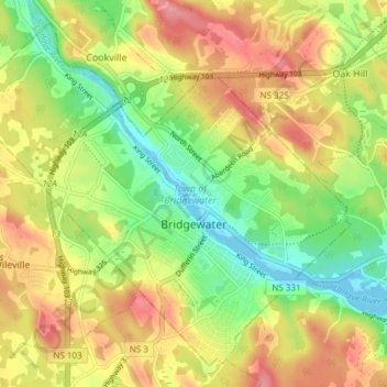
Nombre: Mapa topográfico Bridgewater, altitud, relieve.
Lugar: Bridgewater, Lunenburg County, Nova Scotia, Canada (44.35760 -64.56427 44.40550 -64.48875)
Altitud media: 56 m
Altitud mínima: -2 m
Altitud máxima: 118 m
Haz una donación
Otros mapas topográficos
Haga clic en un mapa para ver su topografía, su altitud y su relieve.