
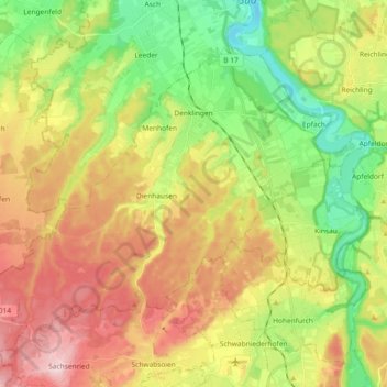
Mapa topográfico Denklingen
Mapa interactivo
Haga clic en el mapa para ver la altitud.
Acerca de este mapa
Nombre: Mapa topográfico Denklingen, altitud, relieve.
Altitud media: 728 m
Altitud mínima: 612 m
Altitud máxima: 867 m
Eishockey: Der VfL Denklingen/Eishockey nahm von 1966 bis 2015 am Spielbetrieb des BEV teil. Die sportlichen Höhepunkte in der Zeit waren 2007 die Meisterschaft der Bayerischen-Bezirksliga Gruppe IV, der Aufstieg in die Bayerische-Landesliga 1983 und 1980 der Aufstieg in die Natureis-Bayernliga. Von 1983 bis 2003 spielte der VfLD durchgehend in der Bayerischen-Landesliga. Von 2010 bis 2015 bildete der VfL eine Spielgemeinschaft mit dem EV Landsberg 1b in der Bezirksliga Bayern. Quelle: rodi-db.de
Otros mapas topográficos
Haga clic en un mapa para ver su topografía, su altitud y su relieve.
Landsberg am Lech
Deutschland > Bayern > Landkreis Landsberg am Lech
Landsberg am Lech, Landkreis Landsberg am Lech, Bayern, 86899, Deutschland
Altitud media: 626 m
Ammersee
Deutschland > Bayern > Landkreis Landsberg am Lech
Ammersee, Landkreis Landsberg am Lech, Bayern, Deutschland
Altitud media: 596 m
Lechmühlen
Deutschland > Bayern > Landkreis Landsberg am Lech > Fuchstal
Lechmühlen, Fuchstal, Landkreis Landsberg am Lech, Bayern, 86925, Deutschland
Altitud media: 653 m
86947
Deutschland > Bayern > Landkreis Landsberg am Lech > Weil
86947, Weil, Landkreis Landsberg am Lech, Bayern, Deutschland
Altitud media: 579 m
86946
Deutschland > Bayern > Landkreis Landsberg am Lech > Pflugdorf
86946, Pflugdorf, Vilgertshofen, Reichling, Landkreis Landsberg am Lech, Bayern, Deutschland
Altitud media: 695 m
82279
Deutschland > Bayern > Landkreis Landsberg am Lech > Eching am Ammersee
82279, Eching am Ammersee, Schondorf a.Ammersee (VGem), Landkreis Landsberg am Lech, Bayern, Deutschland
Altitud media: 543 m
86919
Deutschland > Bayern > Landkreis Landsberg am Lech > Utting am Ammersee
86919, Utting am Ammersee, Landkreis Landsberg am Lech, Bayern, Deutschland
Altitud media: 565 m
Holzhausen bei Buchloe
Deutschland > Bayern > Landkreis Landsberg am Lech
Holzhausen bei Buchloe, Igling, Landkreis Landsberg am Lech, Bayern, 86859, Deutschland
Altitud media: 618 m
Oberbergen
Deutschland > Bayern > Landkreis Landsberg am Lech
Oberbergen, Penzing, Landkreis Landsberg am Lech, Bayern, 86929, Deutschland
Altitud media: 602 m
Greifenberg
Deutschland > Bayern > Landkreis Landsberg am Lech
Greifenberg, Schondorf a.Ammersee (VGem), Landkreis Landsberg am Lech, Bayern, 86926, Deutschland
Altitud media: 575 m
Schöffelding
Deutschland > Bayern > Landkreis Landsberg am Lech
Schöffelding, Windach, Landkreis Landsberg am Lech, Bayern, 86949, Deutschland
Altitud media: 631 m
Schwifting
Deutschland > Bayern > Landkreis Landsberg am Lech
Schwifting, Pürgen, Landkreis Landsberg am Lech, Bayern, 86940, Deutschland
Altitud media: 634 m
Pflugdorf
Deutschland > Bayern > Landkreis Landsberg am Lech
Pflugdorf, Vilgertshofen, Reichling, Landkreis Landsberg am Lech, Bayern, 86946, Deutschland
Altitud media: 689 m
Unterdießen
Deutschland > Bayern > Landkreis Landsberg am Lech
Unterdießen, Fuchstal, Landkreis Landsberg am Lech, Bayern, 86944, Deutschland
Altitud media: 650 m
Dießen am Ammersee
Deutschland > Bayern > Landkreis Landsberg am Lech
Dießen am Ammersee, Landkreis Landsberg am Lech, Bayern, 86911, Deutschland
Altitud media: 594 m
Welden
Deutschland > Bayern > Landkreis Landsberg am Lech > Fuchstal
Welden, Fuchstal, Landkreis Landsberg am Lech, Bayern, 86925, Deutschland
Altitud media: 721 m
Scheuring
Deutschland > Bayern > Landkreis Landsberg am Lech
Scheuring, Prittriching, Landkreis Landsberg am Lech, Bayern, 86937, Deutschland
Altitud media: 565 m
Ludenhausen
Deutschland > Bayern > Landkreis Landsberg am Lech
Ludenhausen, Reichling, Landkreis Landsberg am Lech, Bayern, 86934, Deutschland
Altitud media: 708 m
86934
Deutschland > Bayern > Landkreis Landsberg am Lech > Reichling
86934, Reichling, Landkreis Landsberg am Lech, Bayern, Deutschland
Altitud media: 710 m
Leeder
Deutschland > Bayern > Landkreis Landsberg am Lech > Fuchstal
Leeder, Fuchstal, Landkreis Landsberg am Lech, Bayern, 86925, Deutschland
Altitud media: 680 m
Dettenschwang
Deutschland > Bayern > Landkreis Landsberg am Lech > Dießen am Ammersee
Dettenschwang, Dießen am Ammersee, Landkreis Landsberg am Lech, Bayern, Deutschland
Altitud media: 675 m
Mundraching
Deutschland > Bayern > Landkreis Landsberg am Lech
Mundraching, Vilgertshofen, Reichling, Landkreis Landsberg am Lech, Bayern, 86925, Deutschland
Altitud media: 657 m
Kaufering
Deutschland > Bayern > Landkreis Landsberg am Lech
Kaufering, Landkreis Landsberg am Lech, Bayern, 86916, Deutschland
Altitud media: 589 m
Igling
Deutschland > Bayern > Landkreis Landsberg am Lech
Igling, Landkreis Landsberg am Lech, Bayern, 86859, Deutschland
Altitud media: 602 m
Schondorf am Ammersee
Deutschland > Bayern > Landkreis Landsberg am Lech
Schondorf am Ammersee, Schondorf a.Ammersee (VGem), Landkreis Landsberg am Lech, Bayern, 86938, Deutschland
Altitud media: 555 m
Thaining
Deutschland > Bayern > Landkreis Landsberg am Lech
Thaining, Reichling, Landkreis Landsberg am Lech, Bayern, 86943, Deutschland
Altitud media: 682 m
Sankt Ottilien
Deutschland > Bayern > Landkreis Landsberg am Lech
Sankt Ottilien, Eresing, Windach, Landkreis Landsberg am Lech, Bayern, 86941, Deutschland
Altitud media: 598 m
Fuchstal
Deutschland > Bayern > Landkreis Landsberg am Lech
Fuchstal, Landkreis Landsberg am Lech, Bayern, 86925, Deutschland
Altitud media: 691 m
Prittriching
Deutschland > Bayern > Landkreis Landsberg am Lech
Prittriching, Landkreis Landsberg am Lech, Bayern, 86931, Deutschland
Altitud media: 544 m
Dornstetten
Deutschland > Bayern > Landkreis Landsberg am Lech
Dornstetten, Unterdießen, Fuchstal, Landkreis Landsberg am Lech, Bayern, 86944, Deutschland
Altitud media: 638 m
Penzing
Deutschland > Bayern > Landkreis Landsberg am Lech
Penzing, Landkreis Landsberg am Lech, Bayern, 86929, Deutschland
Altitud media: 610 m
Geltendorf
Deutschland > Bayern > Landkreis Landsberg am Lech
Geltendorf, Landkreis Landsberg am Lech, Bayern, 82269, Deutschland
Altitud media: 586 m
Kinsau
Deutschland > Bayern > Landkreis Landsberg am Lech
Kinsau, Reichling, Landkreis Landsberg am Lech, Bayern, 86981, Deutschland
Altitud media: 700 m
Egling an der Paar
Deutschland > Bayern > Landkreis Landsberg am Lech > Egling an der Paar
Egling an der Paar, Landkreis Landsberg am Lech, Bayern, 86492, Deutschland
Altitud media: 561 m
Reichling
Deutschland > Bayern > Landkreis Landsberg am Lech > Reichling
Reichling, Landkreis Landsberg am Lech, Bayern, 86934, Deutschland
Altitud media: 691 m
Ammersee
Deutschland > Bayern > Landkreis Landsberg am Lech > Schondorf am Ammersee
Ammersee, Schondorf am Ammersee, Schondorf a.Ammersee (VGem), Landkreis Landsberg am Lech, Bayern, Deutschland
Altitud media: 596 m
Hurlach
Deutschland > Bayern > Landkreis Landsberg am Lech
Hurlach, Igling, Landkreis Landsberg am Lech, Bayern, 86857, Deutschland
Altitud media: 579 m
Pessenhausen
Deutschland > Bayern > Landkreis Landsberg am Lech > Pessenhausen
Pessenhausen, Rott, Reichling, Landkreis Landsberg am Lech, Bayern, 86934, Deutschland
Altitud media: 706 m
Utting am Ammersee
Deutschland > Bayern > Landkreis Landsberg am Lech
Utting am Ammersee, Landkreis Landsberg am Lech, Bayern, 86919, Deutschland
Altitud media: 573 m
Oberdießen
Deutschland > Bayern > Landkreis Landsberg am Lech > Oberdießen
Oberdießen, Unterdießen, Fuchstal, Landkreis Landsberg am Lech, Bayern, 86944, Deutschland
Altitud media: 660 m
Finning
Deutschland > Bayern > Landkreis Landsberg am Lech
Finning, Windach, Landkreis Landsberg am Lech, Bayern, 86923, Deutschland
Altitud media: 635 m
Eresing
Deutschland > Bayern > Landkreis Landsberg am Lech
Eresing, Windach, Landkreis Landsberg am Lech, Bayern, Deutschland
Altitud media: 602 m
Vilgertshofen
Deutschland > Bayern > Landkreis Landsberg am Lech
Vilgertshofen, Reichling, Landkreis Landsberg am Lech, Bayern, 86946, Deutschland
Altitud media: 681 m
Windach
Deutschland > Bayern > Landkreis Landsberg am Lech
Windach, Landkreis Landsberg am Lech, Bayern, 86949, Deutschland
Altitud media: 603 m