
Mapa topográfico Lake George
Haga clic en el mapa para ver la altitud.
Lake George
About 42.3 miles (68.1 km) northwest of Colorado Springs and 7.3 miles (11.7 km) northwest of Florissant, the town of Lake George was established in 1891 as a railroad stop for the Colorado Midland Railway (CM) which had been completed in 1887. The town and nearby lake—to its west and fed by the South Platte River—The man made lake was built by George Frost for the purpose of supplying ice to the railroad. The lake, originally called George's Lake was later changed to Lake George when the post office opened. The lake itself freezes mostly solid in the wintertime, which made it ideal for railroad men to cut large blocks of ice from it in order to keep perishables cool. A privately owned ice company here supplied the needs of much of the Pikes Peak region. Ice cut during the winter was shipped on the CM to both Colorado Springs and the Cripple Creek, Colorado district. Also related to the town's railroading history, a short walk into the surrounding hills reveals Chinese bread ovens, from the period their labor was imported. At the turn of the century the community's population was 30. After 1900 some farmers and ranchers nearby began raising high-altitude potatoes on a limited scale. This furnished the CM with some additional traffic. However, the CM closed in August 1918. Other railways then provided service to certain shippers along the otherwise idle CM railway. Up to that time this had been the shortest rail route through the mountains. Keeping the track open during winter proved expensive, and when the mining of ore dwindled, the tracks were torn up. U.S. Route 24 follows the abandoned grade of the CM railway. By 1941 the community had grown to 100 persons and was the center of an extensive potato growing area. The community's population in 1965 was 100.
Acerca de este mapa
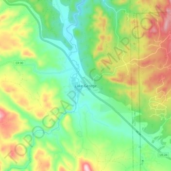
Nombre: Mapa topográfico Lake George, altitud, relieve.
Lugar: Lake George, Park County, Colorado, United States (38.94040 -105.39843 39.02040 -105.31843)
Altitud media: 2.543 m
Altitud mínima: 2.397 m
Altitud máxima: 2.790 m
Otros mapas topográficos
Haga clic en un mapa para ver su topografía, su altitud y su relieve.
Fairplay
United States > Colorado > Park County
The historic Town of Fairplay is the Statutory Town that is the county seat and the most populous municipality of Park County, Colorado, United States. The town population was 724 at the 2020 United States Census. Fairplay is located in South Park at an elevation of 9,953 feet (3,034 m). The town is the…
Altitud media: 3.045 m
Alma
United States > Colorado > Park County
At an elevation of approximately 10,578 feet (3,224 m), Alma is the highest incorporated municipality in the United States when considering only areas with permanent residents. Its post office is located at the highest elevation of any in the country. Alma, which is considered a town and not a city, does not…
Altitud media: 3.212 m
Fairplay
United States > Colorado > Park County
The historic Town of Fairplay is the Statutory Town that is the county seat and the most populous municipality of Park County, Colorado, United States. The town population was 724 at the 2020 United States Census. Fairplay is located in South Park at an elevation of 9,953 feet (3,034 m). The town is the…
Altitud media: 3.045 m
Fairplay
United States > Colorado > Park County
The historic Town of Fairplay is the Statutory Town that is the county seat and the most populous municipality of Park County, Colorado, United States. The town population was 724 at the 2020 United States Census. Fairplay is located in South Park at an elevation of 9,953 feet (3,034 m). The town is the…
Altitud media: 3.040 m
Alma
United States > Colorado > Park County
At an elevation of approximately 10,522 feet (3,207 m), Alma is the highest incorporated municipality in the United States when considering only areas with permanent residents. Its post office is located at the highest elevation of any in the country. Alma, which is considered a town and not a city, does not…
Altitud media: 3.212 m
Fairplay
United States > Colorado > Park County
Fairplay is a statutory town that is the county seat and the most populous municipality of Park County, Colorado, United States. The town population was 724 at the 2020 United States Census. Fairplay is located in South Park at an elevation of 9,953 feet (3,034 m). The town is the fifth-highest incorporated…
Altitud media: 3.045 m
Alma
United States > Colorado > Park County
At an elevation of approximately 10,522 feet (3,207 m), Alma is the highest incorporated municipality in the United States when considering only areas with permanent residents. Its post office is located at the highest elevation of any in the country. Alma, which is considered a town and not a city, does not…
Altitud media: 3.212 m
Alma
United States > Colorado > Park County
At an elevation of 10,361 feet (3,158 m), Alma is the highest incorporated municipality in the United States when considering only areas with permanent residents. Its post office is located at the highest elevation of any in the country. Alma, which is considered a town and not a city, does not take the title…
Altitud media: 3.212 m