
Haz una donación
Mapa topográfico Stabiziane
Haga clic en el mapa para ver la altitud.
Haz una donación
Acerca de este mapa
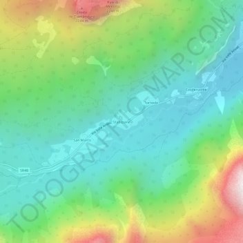
Nombre: Mapa topográfico Stabiziane, altitud, relieve.
Lugar: Stabiziane, Auronzo di Cadore, Belluno, Veneto, 32041, Italy (46.51904 12.28428 46.55904 12.32428)
Altitud media: 1.460 m
Altitud mínima: 1.005 m
Altitud máxima: 2.495 m
Haz una donación
Otros mapas topográficos
Haga clic en un mapa para ver su topografía, su altitud y su relieve.
Tre Cime di Lavaredo - Drei Zinnen
Italy > Veneto > Belluno > Auronzo di Cadore
Until 1919 the peaks formed part of the border between Italy and Austria-Hungary. Now they lie on the border between the Italian provinces of South Tyrol and Belluno and still are a part of the linguistic boundary between German-speaking and Italian-speaking majorities. The Cima Grande has an elevation of…
Altitud media: 2.242 m