
Mapa topográfico Sehore
Mapa interactivo
Haga clic en el mapa para ver la altitud.
Acerca de este mapa
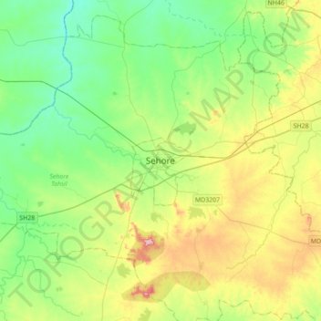
Nombre: Mapa topográfico Sehore, altitud, relieve.
Altitud media: 501 m
Altitud mínima: 449 m
Altitud máxima: 611 m
Sehore is 37 km from the state capital, Bhopal, towards the south-west and on the Bhopal - Indore highway. Its height from mean sea level is between 1500 ft. and 2000 ft. Sehore is situated on the Western Railway line from Bhopal to Ratlam. It is surrounded by 7 districts: Bhopal, Raisen, Harda, Hoshangabad, Dewas, Shajapur and Rajgarh. Sehore district extends between the parallels of Latitude 22'31 to 23'40 North and between the meridians of Longitude 76'22 and 78'08 East. Sehore is located at 23°12′N 77°05′E / 23.2°N 77.08°E / 23.2; 77.08. It has an average elevation of 502 metres (1646 feet). The only river passing through the Sehore district is the Siven.