
Gracias por apoyar a este sitio ❤️
Haz una donación
Haz una donación
Mapa topográfico Cottonwood River
Haga clic en el mapa para ver la altitud.
Gracias por apoyar a este sitio ❤️
Haz una donación
Haz una donación
Acerca de este mapa
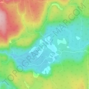
Nombre: Mapa topográfico Cottonwood River, altitud, relieve.
Altitud media: 799 m
Altitud mínima: 728 m
Altitud máxima: 916 m
Gracias por apoyar a este sitio ❤️
Haz una donación
Haz una donación
Otros mapas topográficos
Haga clic en un mapa para ver su topografía, su altitud y su relieve.
Barkerville
Canada > British Columbia > Cariboo Regional District > Area C (Bowron Lake/Barlow Creek/Barkerville)
Barkerville has a subarctic climate (Köppen climate classification Dfc), which makes it have long, cold and snowy winter and short and cool summers due to its high altitude and latitude. Its growing season averages only 66 days.
Altitud media: 1.435 m