
Mapa topográfico Morganville
Mapa interactivo
Haga clic en el mapa para ver la altitud.
Acerca de este mapa
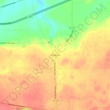
Nombre: Mapa topográfico Morganville, altitud, relieve.
Altitud media: 261 m
Altitud mínima: 220 m
Altitud máxima: 287 m
Otros mapas topográficos
Haga clic en un mapa para ver su topografía, su altitud y su relieve.
Roanoke
United States > New York > Genesee County > Town of Stafford
Roanoke, Town of Stafford, Genesee County, New York, 14143, United States
Altitud media: 287 m