
Mapa topográfico Nathdwara
Mapa interactivo
Haga clic en el mapa para ver la altitud.
Nathdwara
Nathdwara is located at 24°56′N 73°49′E / 24.93°N 73.82°E / 24.93; 73.82. It has an average elevation of 584 metres (1919 ft). Located just 48 km north-east of Udaipur in Rajasthan, this town is easily reached by air, road or nearest rail-head.
Acerca de este mapa
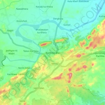
Nombre: Mapa topográfico Nathdwara, altitud, relieve.
Altitud media: 590 m
Altitud mínima: 538 m
Altitud máxima: 713 m