
Haz una donación
Mapa topográfico Olivebridge
Haga clic en el mapa para ver la altitud.
Haz una donación
Acerca de este mapa
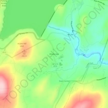
Nombre: Mapa topográfico Olivebridge, altitud, relieve.
Altitud media: 189 m
Altitud mínima: 105 m
Altitud máxima: 322 m
Haz una donación
Otros mapas topográficos
Haga clic en un mapa para ver su topografía, su altitud y su relieve.
Village of Ellenville
United States > New York > Ulster County > Town of Wawarsing
Altitud media: 325 m
Haz una donación
Catskills Visitor Center
United States > New York > Ulster County > Town of Shandaken > Beechford
Altitud media: 301 m
Haz una donación
Haz una donación
Village of Ellenville
United States > New York > Ulster County > Town of Wawarsing
Altitud media: 325 m
Haz una donación
Cooper Lake
United States > New York > Ulster County > Town of Woodstock > Lake Hill
Altitud media: 367 m
Haz una donación
Haz una donación
Haz una donación
Woodland Valley Campground
United States > New York > Ulster County > Town of Shandaken
Altitud media: 565 m
Minnewaska State Park Preserve
United States > New York > Ulster County > Town of Wawarsing
Altitud media: 279 m
Haz una donación
Village of Ellenville
United States > New York > Ulster County > Town of Wawarsing
Altitud media: 325 m
Haz una donación
Town of Denning
United States > New York > Ulster County
The town is in the Catskill Mountains and borders Sullivan County, New York. It is rugged and heavily wooded. Most settlement is concentrated around the hamlet of Sundown on Rondout Creek, along the two branches of the Neversink River or in the plateau between the two valleys northeast of Red Hill, at…
Altitud media: 663 m
Haz una donación
Haz una donación
Village of Ellenville
United States > New York > Ulster County > Town of Wawarsing
Altitud media: 325 m
Phoenicia
United States > New York > Ulster County > Town of Shandaken > Phoenicia
Altitud media: 349 m
Catskills Visitor Center
United States > New York > Ulster County > Town of Shandaken > Beechford
Altitud media: 301 m
Haz una donación
Haz una donación
Town of Denning
United States > New York > Ulster County
The town is in the Catskill Mountains and borders Sullivan County, New York. It is rugged and heavily wooded. Most settlement is concentrated around the hamlet of Sundown on Rondout Creek, along the two branches of the Neversink River or in the plateau between the two valleys northeast of Red Hill, at…
Altitud media: 663 m
Haz una donación
Haz una donación
Town of Denning
United States > New York > Ulster County
The town is in the Catskill Mountains and borders Sullivan County, New York. It is rugged and heavily wooded. Most settlement is concentrated around the hamlet of Sundown on Rondout Creek, along the two branches of the Neversink River or in the plateau between the two valleys northeast of Red Hill, at…
Altitud media: 663 m