
Haz una donación
Mapa topográfico Midland
Haga clic en el mapa para ver la altitud.
Haz una donación
Acerca de este mapa
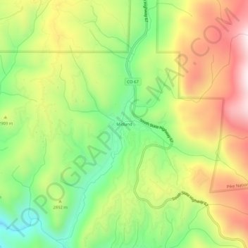
Nombre: Mapa topográfico Midland, altitud, relieve.
Lugar: Midland, Teller County, Colorado, United States (38.83832 -105.18165 38.87832 -105.14165)
Altitud media: 2.874 m
Altitud mínima: 2.592 m
Altitud máxima: 3.199 m
Haz una donación
Otros mapas topográficos
Haga clic en un mapa para ver su topografía, su altitud y su relieve.
Woodland Park
United States > Colorado > Teller County
The area is characterized by the abundance of large granite rocks and alpine meadows, as well as its consistently high elevation ranging between 8,200 and 10,000 feet above sea level. The climate is considered arid which causes the surrounding forests to become very dry, posing a significant fire threat in…
Altitud media: 2.652 m
Cripple Creek
United States > Colorado > Teller County
For many years, Cripple Creek's high valley, at an elevation of 9,494 feet (2,894 m), was considered no more important than a cattle pasture. Many prospectors avoided the area after the Mount Pisgah hoax, a mini gold rush caused by salting (adding gold to worthless rock).
Altitud media: 2.946 m
Victor
United States > Colorado > Teller County
In 2022, youtubers The Baseball Bat Bros attempted to break the Guinness World Record for Longest home run hit, set by Babe Ruth in 1921 with a verified measurement of 575 feet. The attempt was made at The Gold Bowl baseball and soccer field. Victor, having one of the highest elevations in the United States…
Altitud media: 2.974 m
Woodland Park
United States > Colorado > Teller County
The area is characterized by the abundance of large granite rocks and alpine meadows, as well as its consistently high elevation ranging between 8,200 and 10,000 feet above sea level. The climate is considered arid which causes the surrounding forests to become very dry, posing a significant fire threat in…
Altitud media: 2.652 m
Haz una donación
Victor
United States > Colorado > Teller County
In 2022, youtubers The Baseball Bat Bros attempted to break the Guinness World Record for Longest home run hit, set by Babe Ruth in 1921 with a verified measurement of 575 feet. The attempt was made at The Gold Bowl baseball and soccer field. Victor, having one of the highest elevations in the United States…
Altitud media: 2.974 m
Florissant Fossil Beds National Monument
United States > Colorado > Teller County
Early estimates of the elevation of the Florissant beds was determined to be between 300–900 meters, much lower than the modern elevation of 2,500-2,600 meters. However, more recent estimates that are based on paleoflora have put the elevation in the Eocene much higher. Ranges from 1,900 to 4,100 meters have…
Altitud media: 2.616 m
Victor
United States > Colorado > Teller County
In 2022, youtubers The Baseball Bat Bros attempted to break the Guinness World Record for Longest home run hit, set by Babe Ruth in 1921 with a verified measurement of 575 feet. The attempt was made at The Gold Bowl baseball and soccer field. Victor, having one of the highest elevations in the United States…
Altitud media: 2.974 m
Woodland Park
United States > Colorado > Teller County
The area is characterized by the abundance of large granite rocks and alpine meadows, as well as its consistently high elevation ranging between 8,200 and 10,000 feet above sea level. The climate is considered arid which causes the surrounding forests to become very dry, posing a significant fire threat in…
Altitud media: 2.652 m
Haz una donación