
Haz una donación
Mapa topográfico Walden
Haga clic en el mapa para ver la altitud.
Haz una donación
Walden
Walden is the Statutory Town that is the county seat, the most populous community, and the only incorporated municipality in Jackson County, Colorado, United States. It is situated in the center of a large open valley called North Park. People from Walden and the surrounding area refer to themselves as "North Parkers". The town population was 606 at the 2020 census. The town sits at an elevation of 8,099 feet (2,469 meters). It was established in 1889 and was incorporated 2 December 1890. Mark A. Walden, an early postmaster, gave the community his name.
Haz una donación
Acerca de este mapa
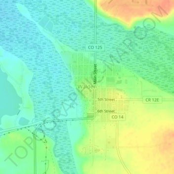
Nombre: Mapa topográfico Walden, altitud, relieve.
Lugar: Walden, Jackson County, Colorado, United States (40.72605 -106.28693 40.73695 -106.27409)
Altitud media: 2.463 m
Altitud mínima: 2.447 m
Altitud máxima: 2.490 m
Haz una donación
Otros mapas topográficos
Haga clic en un mapa para ver su topografía, su altitud y su relieve.
Walden
United States > Colorado > Jackson County
Walden is the Statutory Town that is the county seat, the most populous community, and the only incorporated municipality in Jackson County, Colorado, United States. It is situated in the center of a large open valley called North Park. People from Walden and the surrounding area refer to themselves as "North…
Altitud media: 2.463 m
Haz una donación