
Mapa topográfico Nutten Hook State Tidal Wetland
Mapa interactivo
Haga clic en el mapa para ver la altitud.
Acerca de este mapa
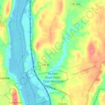
Nombre: Mapa topográfico Nutten Hook State Tidal Wetland, altitud, relieve.
Altitud media: 32 m
Altitud mínima: -5 m
Altitud máxima: 81 m
Otros mapas topográficos
Haga clic en un mapa para ver su topografía, su altitud y su relieve.
Stuyvesant Falls
United States > New York > Columbia County > Town of Stuyvesant
Stuyvesant Falls, Town of Stuyvesant, Columbia County, New York, 12174, United States
Altitud media: 58 m
Newton Hook
United States > New York > Columbia County > Town of Stuyvesant
Newton Hook, Town of Stuyvesant, Columbia County, New York, 12173, United States
Altitud media: 26 m
Poolsburg
United States > New York > Columbia County > Town of Stuyvesant
Poolsburg, Town of Stuyvesant, Columbia County, New York, 12124, United States
Altitud media: 39 m