
Mapa topográfico Pointe Emma
Mapa interactivo
Haga clic en el mapa para ver la altitud.
Acerca de este mapa
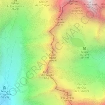
Nombre: Mapa topográfico Pointe Emma, altitud, relieve.
Altitud media: 2.895 m
Altitud mínima: 2.152 m
Altitud máxima: 3.852 m
Otros mapas topográficos
Haga clic en un mapa para ver su topografía, su altitud y su relieve.
Pic d'Arsine
France > Provence-Alpes-Côte d'Azur > Villar-d'Arêne
Pic d'Arsine, Villar-d'Arêne, Briançon, Hautes-Alpes, Provence-Alpes-Côte d'Azur, France métropolitaine, 05480, France
Altitud media: 2.859 m
La Grande Ruine
France > Provence-Alpes-Côte d'Azur > Villar-d'Arêne
La Grande Ruine, Villar-d'Arêne, Briançon, Hautes-Alpes, Provence-Alpes-Côte d'Azur, France métropolitaine, 05480, France
Altitud media: 3.067 m
Réserve naturelle du versant Nord des pics de Combeynot
France > Provence-Alpes-Côte d'Azur > Villar-d'Arêne
Réserve naturelle du versant Nord des pics de Combeynot, D 1091, Villar-d'Arêne, Briançon, Hautes-Alpes, Provence-Alpes-Côte d'Azur, France métropolitaine, 05480, France
Altitud media: 2.335 m
Plan d'eau d'Arsine
France > Provence-Alpes-Côte d'Azur > Villar-d'Arêne
Plan d'eau d'Arsine, Pont d'Arsine, Villar-d'Arêne, Briançon, Hautes-Alpes, Provence-Alpes-Côte d'Azur, France métropolitaine, 05480, France
Altitud media: 1.966 m
Lac du Goléon
France > Provence-Alpes-Côte d'Azur > Villar-d'Arêne
Lac du Goléon, D 1091, Villar-d'Arêne, Briançon, Hautes-Alpes, Provence-Alpes-Côte d'Azur, France métropolitaine, 05480, France
Altitud media: 2.580 m