
Mapa topográfico River Lune
Mapa interactivo
Haga clic en el mapa para ver la altitud.
River Lune
The river begins as a stream at Newbiggin, in the parish of Ravenstonedale, Cumbria, at St. Helen's Well (elevation of 238 metres (781 ft) above sea level) and some neighbouring springs. On the first two miles of its course, it is joined by four streams, two of them as short as itself, but two much longer. These are the Bessy Beck (short), the Dry Beck of 4.9 kilometres' (three miles) length at 0.32 miles (0.51 km) from St. Helen's Well, the Sandwath Beck (short) at 0.37 miles (0.60 km), and the Weasdale Beck (5.58 km = 3½ mls) at 1.6 miles from the well. Weasdale Beck is the uppermost headwater of River Lune recorded in Environment Agency's Catchment Data Explorer.
Acerca de este mapa
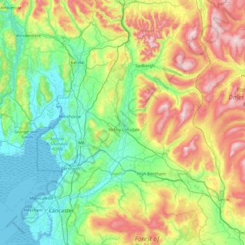
Nombre: Mapa topográfico River Lune, altitud, relieve.
Lugar: River Lune, Cumbria, England, CA17 4NB, United Kingdom (53.98348 -2.88241 54.44606 -2.45200)
Altitud media: 220 m
Altitud mínima: 0 m
Altitud máxima: 729 m
Otros mapas topográficos
Haga clic en un mapa para ver su topografía, su altitud y su relieve.
Glenridding Dodd
United Kingdom > England > Cumbria > Patterdale
Glenridding Dodd (the rounded hill above Glenridding) is a small fell in the English Lake District, at the end of a ridge descending from the Helvellyn range in the Eastern Fells. It stands above the village of Glenridding and on the western shore of Ullswater. Although small and not of great elevation, its…
Altitud media: 298 m
Redhills Quarry (disused, flooded)
United Kingdom > England > Cumbria > Borough of Copeland > Millom > Rottington
Altitud media: 6 m
Whitestone Moss
United Kingdom > England > Cumbria > South Lakeland > High Nibthwaite > Houkler Hall
Altitud media: 102 m
Storrs
United Kingdom > England > Cumbria > South Lakeland > Bowness-on-Windermere
Altitud media: 93 m
Dufton Pike
United Kingdom > England > Cumbria > Eden District
Dufton Pike is a hill in the northern Pennines, in Cumbria, England. It is classed as a Marilyn (a hill with topographic prominence of at least 150m). It rises above the village of Dufton.
Altitud media: 313 m
Oughterby
United Kingdom > England > Cumbria > Allerdale > Kirkbampton > Oughterby
Altitud media: 35 m
Bowscale Fell
United Kingdom > England > Cumbria > Eden
Being on the Derwent - Eden watershed, Bowscale Fell has further topographical significance by providing the link between the Northern and Eastern Fells. The eastern ridge continues almost imperceptibly beneath Raven Crag, crossing the road before rising again to form Little Eycott and Eycott Hills. From here…
Altitud media: 511 m
High Cup Nick
United Kingdom > England > Cumbria > Murton
The Pennine Way skirts the valley on its northern side by a traditional route known as Narrow Gate as it runs from Forest in Teesdale west via Cauldron Snout and Maize Beck to Dufton. This national trail briefly splits into two separate routes on either bank of Maize Beck; it is the southerly of the two which…
Altitud media: 601 m
Hay Stacks
United Kingdom > England > Cumbria > Allerdale
Haystacks, or Hay Stacks, is a hill in England's Lake District, situated at the south-eastern end of the Buttermere Valley. Although not of any great elevation (597 m, 1,958 ft), Haystacks has become one of the most popular fells in the area. This fame is partly due to the writings of Alfred Wainwright, who…
Altitud media: 378 m
Mealsgate
United Kingdom > England > Cumbria > Allerdale > Mealsgate > Fletchertown
Altitud media: 104 m
Milefortlet 9, Skinburness
United Kingdom > England > Cumbria > Allerdale > Skinburness
Altitud media: 3 m