
Haz una donación
Mapa topográfico Grays Peak
Haga clic en el mapa para ver la altitud.
Haz una donación
Grays Peak
Grays Peak is one of 53 fourteeners (mountains of over 14,000 feet (4,300 m) in elevation) in Colorado. Botanist Charles C. Parry made the first recorded ascent of the summit in 1861 and named the peak in honor of his botanist colleague Asa Gray. Gray did not see (and climb) the peak until 1872, eleven years later. Grays Peak is commonly mentioned in conjunction with adjacent Torreys Peak. In the Arapaho language Gray's Peak and the adjacent Torrey's Peak are named, Heeniiyoowuu or "Ant Hills".
Haz una donación
Acerca de este mapa
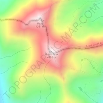
Nombre: Mapa topográfico Grays Peak, altitud, relieve.
Altitud media: 3.914 m
Altitud mínima: 3.497 m
Altitud máxima: 4.341 m
Haz una donación
Otros mapas topográficos
Haga clic en un mapa para ver su topografía, su altitud y su relieve.
Georgetown
United States > Colorado > Clear Creek County
The town sits at an elevation of 8,530 feet (2,600 m) above sea level, nestled in the mountains near the upper end of the valley of Clear Creek in the mountains west of Denver along Interstate 70. Although population was only about 1,000 at the 2010 census, the town was a historic center of the mining industry…
Altitud media: 2.974 m
Haz una donación
Haz una donación
Georgetown
United States > Colorado > Clear Creek County
The town sits at an elevation of 8,530 feet (2,600 m) above sea level, nestled in the mountains near the upper end of the valley of Clear Creek in the mountains west of Denver along Interstate 70. Although population was only about 1,000 at the 2010 census, the town was a historic center of the mining industry…
Altitud media: 2.974 m