Mapa topográfico Scheidegg
Mapa interactivo
Haga clic en el mapa para ver la altitud.
Acerca de este mapa
![Mapa topográfico Scheidegg, altitud, relieve](/pub/maps/relation/d8dn/28m5rr/thumbnail.jpg)
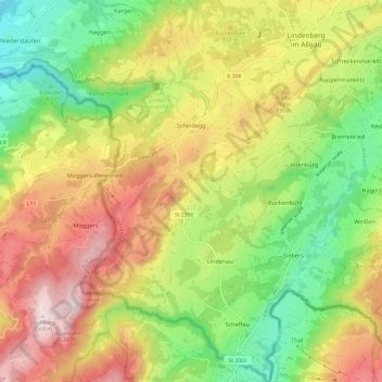
Nombre: Mapa topográfico Scheidegg, altitud, relieve.
Lugar: Scheidegg, Landkreis Lindau, Bayern, 88175, Deutschland (47.52854 9.81507 47.60993 9.88924)
Altitud media: 748 m
Altitud mínima: 478 m
Altitud máxima: 1.070 m
Naturräumlich liegt die Gemeinde am Hang eines Bergrückens, der aus gefalteter Süßwassermolasse aufgebaut ist und sich vom Pfänder oberhalb von Bregenz bis über Lindenberg hinaus von Westsüdwest nach Ostnordost zieht. Das Gemeindegebiet befindet sich in einem Höhenbereich von 600 bis 1000 m ü. NHN.
Otros mapas topográficos
Haga clic en un mapa para ver su topografía, su altitud y su relieve.
![Mapa topográfico Lindau (Bodensee), altitud, relieve](/pub/maps/relation/mncz/mk71z4/icon.jpg)
Lindau (Bodensee)
Deutschland > Bayern > Landkreis Lindau
Lindau (Bodensee), Landkreis Lindau, Bayern, 88131, Deutschland
Altitud media: 448 m
![Mapa topográfico Bad Schachen, altitud, relieve](/pub/maps/node/5f5k/76pdfs8/icon.jpg)
Bad Schachen
Deutschland > Bayern > Landkreis Lindau > Lindau (Bodensee)
Bad Schachen, Lindau (Bodensee), Landkreis Lindau, Bayern, 88131, Deutschland
Altitud media: 412 m
![Mapa topográfico Hergensweiler, altitud, relieve](/pub/maps/relation/xd9m/h6drtp/icon.jpg)
Hergensweiler
Deutschland > Bayern > Landkreis Lindau
Hergensweiler, Sigmarszell (VGem), Landkreis Lindau, Bayern, Deutschland
Altitud media: 539 m
![Mapa topográfico Sigmarszell, altitud, relieve](/pub/maps/relation/ks1h/w2rfnx/icon.jpg)
Sigmarszell
Deutschland > Bayern > Landkreis Lindau
Sigmarszell, Sigmarszell (VGem), Landkreis Lindau, Bayern, 88138, Deutschland
Altitud media: 561 m
![Mapa topográfico Maierhöfen, altitud, relieve](/pub/maps/relation/w1s8/d55btf/icon.jpg)
Maierhöfen
Deutschland > Bayern > Landkreis Lindau
Maierhöfen, Argental (VGem), Landkreis Lindau, Bayern, Deutschland
Altitud media: 772 m
![Mapa topográfico Hinterschweinhöf, altitud, relieve](/pub/maps/node/ztt6/2gzl56tj/icon.jpg)
Hinterschweinhöf
Deutschland > Bayern > Landkreis Lindau > Oberreute
Hinterschweinhöf, Oberreute, Stiefenhofen (VGem), Landkreis Lindau, Bayern, 88179, Deutschland
Altitud media: 876 m
![Mapa topográfico Ried, altitud, relieve](/pub/maps/node/lxs8/bn3hlgt/icon.jpg)
Ried
Deutschland > Bayern > Landkreis Lindau > Lindenberg im Allgäu
Ried, Lindenberg im Allgäu, Weiler-Simmerberg, Landkreis Lindau, Bayern, 88161, Deutschland
Altitud media: 730 m
![Mapa topográfico Böserscheidegg, altitud, relieve](/pub/maps/node/fwf3/tdgk5t6/icon.jpg)
Böserscheidegg
Deutschland > Bayern > Landkreis Lindau > Scheidegg
Böserscheidegg, Scheidegg, Weiler-Simmerberg, Landkreis Lindau, Bayern, 88175, Deutschland
Altitud media: 735 m
![Mapa topográfico Lindenberg im Allgäu, altitud, relieve](/pub/maps/relation/2rtj/55sgp/icon.jpg)
Lindenberg im Allgäu
Deutschland > Bayern > Landkreis Lindau
Lindenberg im Allgäu, Landkreis Lindau, Bayern, 88161, Deutschland
Altitud media: 738 m
![Mapa topográfico Wannental, altitud, relieve](/pub/maps/node/29tj/mzxww9tp/icon.jpg)
Wannental
Deutschland > Bayern > Landkreis Lindau > Lindau (Bodensee)
Wannental, Lindau (Bodensee), Landkreis Lindau, Bayern, 88131, Deutschland
Altitud media: 431 m
![Mapa topográfico Höhenreute, altitud, relieve](/pub/maps/node/tkm2/ctrq9xtj/icon.jpg)
Höhenreute
Deutschland > Bayern > Landkreis Lindau > Lindau (Bodensee)
Höhenreute, Lindau (Bodensee), Landkreis Lindau, Bayern, 88147, Deutschland
Altitud media: 492 m
![Mapa topográfico Oberschwenden, altitud, relieve](/pub/maps/node/gsf3/rssnnv5k/icon.jpg)
Oberschwenden
Deutschland > Bayern > Landkreis Lindau > Scheidegg
Oberschwenden, Scheidegg, Landkreis Lindau, Bayern, 88175, Deutschland
Altitud media: 839 m
![Mapa topográfico Obere Weberei, altitud, relieve](/pub/maps/node/dcb3/7g7rw5rr/icon.jpg)
Obere Weberei
Deutschland > Bayern > Landkreis Lindau > Weiler-Simmerberg > Weiler im Allgäu
Obere Weberei, Weiler im Allgäu, Weiler-Simmerberg, Landkreis Lindau, Bayern, 88171, Deutschland
Altitud media: 696 m
![Mapa topográfico Obernützenbrugg, altitud, relieve](/pub/maps/node/zl57/wz618cz/icon.jpg)
Obernützenbrugg
Deutschland > Bayern > Landkreis Lindau > Hergensweiler
Obernützenbrugg, Hergensweiler, Sigmarszell (VGem), Landkreis Lindau, Bayern, 88145, Deutschland
Altitud media: 552 m
![Mapa topográfico Haus, altitud, relieve](/pub/maps/node/wtf/x5crpnh/icon.jpg)
Haus
Deutschland > Bayern > Landkreis Lindau > Scheidegg
Haus, Scheidegg, Landkreis Lindau, Bayern, 88175, Deutschland
Altitud media: 773 m
![Mapa topográfico Bremenried, altitud, relieve](/pub/maps/node/4dmt/qhf86z4/icon.jpg)
Bremenried
Deutschland > Bayern > Landkreis Lindau > Weiler im Allgäu
Bremenried, Weiler im Allgäu, Weiler-Simmerberg, Landkreis Lindau, Bayern, 88161, Deutschland
Altitud media: 694 m
![Mapa topográfico Rentershofen, altitud, relieve](/pub/maps/node/v8rr/vvjfd3m2/icon.jpg)
Rentershofen
Deutschland > Bayern > Landkreis Lindau > Röthenbach (Allgäu) > Oberhäuser
Rentershofen, Oberhäuser, Röthenbach (Allgäu), Argental (VGem), Landkreis Lindau, Bayern, 88167, Deutschland
Altitud media: 705 m
![Mapa topográfico Oberreutin, altitud, relieve](/pub/maps/node/g357/8cwggxnh/icon.jpg)
Oberreutin
Deutschland > Bayern > Landkreis Lindau > Lindau (Bodensee)
Oberreutin, Lindau (Bodensee), Landkreis Lindau, Bayern, 88131, Deutschland
Altitud media: 433 m
![Mapa topográfico Lengatz, altitud, relieve](/pub/maps/node/7lb3/kpx8b8t6/icon.jpg)
Lengatz
Deutschland > Bayern > Landkreis Lindau > Hergatz
Lengatz, Hergatz, Landkreis Lindau, Bayern, 88178, Deutschland
Altitud media: 636 m
![Mapa topográfico Oberreute, altitud, relieve](/pub/maps/relation/lg51/tffldn/icon.jpg)
Oberreute
Deutschland > Bayern > Landkreis Lindau
Oberreute, Stiefenhofen (VGem), Landkreis Lindau, Bayern, 88179, Deutschland
Altitud media: 830 m
![Mapa topográfico Goßholz, altitud, relieve](/pub/maps/node/dxs8/rk9c8kl/icon.jpg)
Goßholz
Deutschland > Bayern > Landkreis Lindau > Lindenberg im Allgäu
Goßholz, Lindenberg im Allgäu, Landkreis Lindau, Bayern, 88178, Deutschland
Altitud media: 714 m
![Mapa topográfico Weiler-Simmerberg, altitud, relieve](/pub/maps/relation/9c14/swwxb3/icon.jpg)
Weiler-Simmerberg
Deutschland > Bayern > Landkreis Lindau
Weiler-Simmerberg, Landkreis Lindau, Bayern, 88171, Deutschland
Altitud media: 755 m
![Mapa topográfico Stockach, altitud, relieve](/pub/maps/node/gtb3/7r77f3q/icon.jpg)
Stockach
Deutschland > Bayern > Landkreis Lindau > Maierhöfen
Stockach, Maierhöfen, Argental (VGem), Landkreis Lindau, Bayern, Deutschland
Altitud media: 810 m
![Mapa topográfico Rickenbach, altitud, relieve](/pub/maps/node/73t6/wrrnldn/icon.jpg)
Rickenbach
Deutschland > Bayern > Landkreis Lindau > Lindau (Bodensee)
Rickenbach, Lindau (Bodensee), Landkreis Lindau, Bayern, 88131, Deutschland
Altitud media: 428 m
![Mapa topográfico 88171, altitud, relieve](/pub/maps/relation/fjzs/txwldn/icon.jpg)
88171
Deutschland > Bayern > Landkreis Lindau > Weiler-Simmerberg > Hagelstein > Au
88171, Au, Hagelstein, Weiler-Simmerberg, Landkreis Lindau, Bayern, Deutschland
Altitud media: 668 m
![Mapa topográfico Rickatshofen, altitud, relieve](/pub/maps/node/4mt/svwprdn/icon.jpg)
Rickatshofen
Deutschland > Bayern > Landkreis Lindau > Lindau (Bodensee) > Unterreitnau
Rickatshofen, Unterreitnau, Lindau (Bodensee), Landkreis Lindau, Bayern, 88142, Deutschland
Altitud media: 458 m
![Mapa topográfico Kimpflen, altitud, relieve](/pub/maps/node/pm51/7gjn6xnh/icon.jpg)
Kimpflen
Deutschland > Bayern > Landkreis Lindau > Röthenbach (Allgäu)
Kimpflen, Röthenbach (Allgäu), Argental (VGem), Landkreis Lindau, Bayern, 88167, Deutschland
Altitud media: 666 m
![Mapa topográfico Wasserburg (Bodensee), altitud, relieve](/pub/maps/relation/xp5k/kwjm57/icon.jpg)
Wasserburg (Bodensee)
Deutschland > Bayern > Landkreis Lindau
Wasserburg (Bodensee), Landkreis Lindau, Bayern, 88142, Deutschland
Altitud media: 423 m
![Mapa topográfico Egghalden, altitud, relieve](/pub/maps/node/s8nh/8nvrnm3q/icon.jpg)
Egghalden
Deutschland > Bayern > Landkreis Lindau > Zeisertsweiler
Egghalden, Zeisertsweiler, Sigmarszell, Sigmarszell (VGem), Landkreis Lindau, Bayern, 88138, Deutschland
Altitud media: 481 m
![Mapa topográfico Wohmbrechts, altitud, relieve](/pub/maps/node/d1mt/fvnx9gp/icon.jpg)
Wohmbrechts
Deutschland > Bayern > Landkreis Lindau
Wohmbrechts, Hergatz, Landkreis Lindau, Bayern, 88145, Deutschland
Altitud media: 585 m
![Mapa topográfico Weiler im Allgäu, altitud, relieve](/pub/maps/node/g9f3/hkj5zkgt/icon.jpg)
Weiler im Allgäu
Deutschland > Bayern > Landkreis Lindau > Weiler im Allgäu
Weiler im Allgäu, Weiler-Simmerberg, Landkreis Lindau, Bayern, 88171, Deutschland
Altitud media: 695 m
![Mapa topográfico Unterreitnau, altitud, relieve](/pub/maps/node/2tf/sspjfmt/icon.jpg)
Unterreitnau
Deutschland > Bayern > Landkreis Lindau > Lindau (Bodensee) > Unterreitnau
Unterreitnau, Lindau (Bodensee), Landkreis Lindau, Bayern, 88142, Deutschland
Altitud media: 461 m
![Mapa topográfico Bechtersweiler, altitud, relieve](/pub/maps/node/lnh/ng315tj/icon.jpg)
Bechtersweiler
Deutschland > Bayern > Landkreis Lindau > Lindau (Bodensee) > Unterreitnau > Bechtersweiler
Bechtersweiler, Unterreitnau, Lindau (Bodensee), Landkreis Lindau, Bayern, 88142, Deutschland
Altitud media: 471 m
![Mapa topográfico Röthenbach (Allgäu), altitud, relieve](/pub/maps/relation/kz1h/w22rnx/icon.jpg)
Röthenbach (Allgäu)
Deutschland > Bayern > Landkreis Lindau
Röthenbach (Allgäu), Argental (VGem), Landkreis Lindau, Bayern, Deutschland
Altitud media: 683 m
![Mapa topográfico Simmerberg, altitud, relieve](/pub/maps/node/xd3l/fl9g551/icon.jpg)
Simmerberg
Deutschland > Bayern > Landkreis Lindau
Simmerberg, Weiler-Simmerberg, Landkreis Lindau, Bayern, 88171, Deutschland
Altitud media: 743 m
![Mapa topográfico Hergatz, altitud, relieve](/pub/maps/relation/h6tj/fbbw3l/icon.jpg)
Hergatz
Deutschland > Bayern > Landkreis Lindau
Hergatz, Landkreis Lindau, Bayern, Deutschland
Altitud media: 584 m
![Mapa topográfico Ebnit, altitud, relieve](/pub/maps/node/89gp/ws3k4614/icon.jpg)
Ebnit
Deutschland > Bayern > Landkreis Lindau > Lindau (Bodensee) > Schönau > Ebnit
Ebnit, Schönau, Lindau (Bodensee), Landkreis Lindau, Bayern, 88131, Deutschland
Altitud media: 444 m
![Mapa topográfico Nonnenhorn, altitud, relieve](/pub/maps/relation/9t57/1tmgm2/icon.jpg)
Nonnenhorn
Deutschland > Bayern > Landkreis Lindau
Nonnenhorn, Landkreis Lindau, Bayern, 88149, Deutschland
Altitud media: 407 m
![Mapa topográfico Stiefenhofen, altitud, relieve](/pub/maps/relation/6qmt/vss351/icon.jpg)
Stiefenhofen
Deutschland > Bayern > Landkreis Lindau
Stiefenhofen, Stiefenhofen (VGem), Landkreis Lindau, Bayern, Deutschland
Altitud media: 819 m
![Mapa topográfico Opfenbach, altitud, relieve](/pub/maps/relation/xr9m/h66ftp/icon.jpg)
Opfenbach
Deutschland > Bayern > Landkreis Lindau
Opfenbach, Landkreis Lindau, Bayern, 88145, Deutschland
Altitud media: 602 m
![Mapa topográfico Gestratz, altitud, relieve](/pub/maps/relation/gvf3/3xx918/icon.jpg)
Gestratz
Deutschland > Bayern > Landkreis Lindau
Gestratz, Argental (VGem), Landkreis Lindau, Bayern, Deutschland
Altitud media: 698 m
![Mapa topográfico Heimenkirch, altitud, relieve](/pub/maps/relation/d5dn/288mrr/icon.jpg)
Heimenkirch
Deutschland > Bayern > Landkreis Lindau
Heimenkirch, Landkreis Lindau, Bayern, 88178, Deutschland
Altitud media: 672 m