
Gracias por apoyar a este sitio ❤️
Haz una donación
Haz una donación
Mapa topográfico Highlandville
Haga clic en el mapa para ver la altitud.
Gracias por apoyar a este sitio ❤️
Haz una donación
Haz una donación
Highlandville
A post office called Highlandville has been in operation since 1872. The city was named on account of its lofty elevation.
Gracias por apoyar a este sitio ❤️
Haz una donación
Haz una donación
Acerca de este mapa
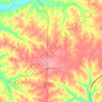
Nombre: Mapa topográfico Highlandville, altitud, relieve.
Lugar: Highlandville, Christian County, Missouri, United States (36.90775 -93.30350 36.98317 -93.26687)
Altitud media: 385 m
Altitud mínima: 319 m
Altitud máxima: 422 m
Gracias por apoyar a este sitio ❤️
Haz una donación
Haz una donación