
Gracias por apoyar a este sitio ❤️
Haz una donación
Haz una donación
Mapa topográfico Allenspark
Haga clic en el mapa para ver la altitud.
Gracias por apoyar a este sitio ❤️
Haz una donación
Haz una donación
Allenspark
Allenspark is located in northwest Boulder County within Roosevelt National Forest in the Front Range of the Colorado Rockies. The western edge of the community is the boundary of Rocky Mountain National Park. State Highway 7 passes through the community, leading north 15 miles (24 km) to Estes Park and east 19 miles (31 km) to Lyons. The center of Allenspark is at an elevation of 8,428 feet (2,569 m).
Gracias por apoyar a este sitio ❤️
Haz una donación
Haz una donación
Acerca de este mapa
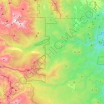
Nombre: Mapa topográfico Allenspark, altitud, relieve.
Lugar: Allenspark, Boulder County, Colorado, United States (40.12942 -105.67155 40.26128 -105.41062)
Altitud media: 2.874 m
Altitud mínima: 1.996 m
Altitud máxima: 4.333 m
Gracias por apoyar a este sitio ❤️
Haz una donación
Haz una donación
Otros mapas topográficos
Haga clic en un mapa para ver su topografía, su altitud y su relieve.