
Mapa topográfico Labuan
Mapa interactivo
Haga clic en el mapa para ver la altitud.
Acerca de este mapa
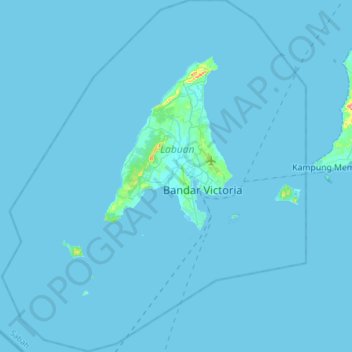
Nombre: Mapa topográfico Labuan, altitud, relieve.
Lugar: Labuan, Malaysia (5.13667 115.06833 5.44167 115.33333)
Altitud media: 1 m
Altitud mínima: 0 m
Altitud máxima: 99 m
Otros mapas topográficos
Haga clic en un mapa para ver su topografía, su altitud y su relieve.
Kampung Indian Settlement Batu Caves
Malaysia > Selangor > Selayang Municipal Council > Batu Caves
Altitud media: 68 m
Gunung Datuk
The main highlight of the mountain is a tor that consists of massive granite boulders, at the elevation of 855 m (2,805 ft).
Altitud media: 455 m
Aur Island
The west coast of Aur Island is influenced by the southwest monsoon that blows the wind from the Straits of Malacca during the months of May to September. The periods between the monsoons are usually marked by heavy rainfall. The mountains have lower temperature range due to their higher altitude and the…
Altitud media: 93 m
Genting Highlands
Genting Highlands is a hill station located on the peak of Mount Ulu Kali in the Titiwangsa Mountains, central Peninsular Malaysia, at 1800 metres elevation. Located in the state of Pahang, it was established in 1965 by the late Malaysian businessman Lim Goh Tong. The primary tourist attraction is Resorts…
Altitud media: 1.141 m