Geolocalizar

Mapa topográfico Ymer Ø

Mapa interactivo

Haga clic en el mapa para ver la altitud.

Acerca de este mapa

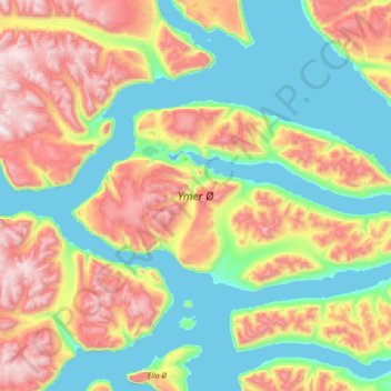
Nombre: Mapa topográfico Ymer Ø, altitud, relieve.

Lugar: Ymer Ø, Sermersooq, Groenlandia (73.02216 -25.75969 73.43278 -22.86959)

Altitud media: 622 m

Altitud mínima: -4 m

Altitud máxima: 2.298 m

Otros mapas topográficos

Haga clic en un mapa para ver su topografía, su altitud y su relieve.

Kullorsuaq

Groenlandia > Kullorsuaq

Kullorsuaq, Avannaata, Groenlandia

Altitud media: 29 m

Sverdrup Ø

Groenlandia

Sverdrup Ø, Groenlandia

Altitud media: 229 m

Milne Land

Groenlandia

Milne Land, Sermersooq, Groenlandia

Altitud media: 39 m

Store Koldewey

Groenlandia

Store Koldewey, Sermersooq, Groenlandia

Altitud media: 40 m

Clavering Ø

Groenlandia

Clavering Ø, Sermersooq, Groenlandia

Altitud media: 381 m

Isla Traill

Groenlandia

Isla Traill, Sermersooq, Groenlandia

Altitud media: 241 m

Kuhn Ø

Groenlandia

Kuhn Ø, Sermersooq, Groenlandia

Altitud media: 185 m

Qeqertarsuaq

Groenlandia

Qeqertarsuaq, Qeqertalik, Groenlandia

Altitud media: 424 m