
Mapa topográfico Beaufort
Mapa interactivo
Haga clic en el mapa para ver la altitud.
Beaufort
Beaufort has an elevation-influenced oceanic climate (Köppen: Cfb), with tepid, relatively dry summers and cool, wetter winters. Average maxima vary from 25.3 °C (77.5 °F) in January to 10.1 °C (50.2 °F) in July, while average minima fluctuate between 11.5 °C (52.7 °F) in February and 3.2 °C (37.8 °F) in July. Mean average annual precipitation is moderately low 685.2 mm (26.98 in), but is frequent, spread between 167.1 precipitation days. Consequently, the town is not sunny, experiencing 180.2 cloudy days and only 55.2 clear days annually. Extreme temperatures have ranged from 44.1 °C (111.4 °F) on 7 February 2009 to −6.0 °C (21.2 °F) on 21 July 1982. All climate data was sourced from Ballarat Airport, located 37.2 kilometres (23.1 mi) southeast of Nhill at slightly higher elevation (435 metres (1,427 ft)).
Acerca de este mapa
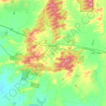
Nombre: Mapa topográfico Beaufort, altitud, relieve.
Lugar: Beaufort, Shire of Pyrenees, Victoria, 3373, Australia (-37.49550 143.22918 -37.38531 143.43986)
Altitud media: 390 m
Altitud mínima: 323 m
Altitud máxima: 513 m
Otros mapas topográficos
Haga clic en un mapa para ver su topografía, su altitud y su relieve.
Ballarat
Ballarat has a moderate oceanic climate (Köppen climate classification Cfb) with four distinct seasons. Its elevation, ranging between 400 and 630 metres (1,310 and 2,070 feet) above sea level, causes its mean monthly temperatures to tend to be on average 3 to 5 °C (5 to 9 °F) below those of Melbourne,…
Altitud media: 470 m
Yarra Valley
Australia > Victoria > Melbourne
The Yarra Valley is the region surrounding the Yarra River in Victoria, Australia. The river originates approximately 240 km (150 mi) east of the Melbourne central business district and flows towards it and out into Port Phillip Bay. The name Yarra Valley is used in reference to the upper regions surrounding…
Altitud media: 305 m
Melbourne
Melbourne is also prone to isolated convective showers forming when a cold pool crosses the state, especially if there is considerable daytime heating. These showers are often heavy and can include hail, squalls, and significant drops in temperature, but they often pass through very quickly with a rapid…
Altitud media: 49 m
Frankston
Australia > Victoria > Frankston
Olivers Hill is the most prominent elevation in Frankston which rises to 55 metres above sea level (180 feet) at its highest point in the suburb. Its origins date to approximately 415 to 360 million years ago. Its base is Mount Eliza Granite dating from the Devonian period, which was covered in lava tuffs in…
Altitud media: 36 m
Mount Dandenong
Australia > Victoria > Melbourne
Mount Dandenong has a cool oceanic climate (Cfb), with cool to mild summers and cold, damp winters. Daytime temperatures are usually 4−6 °C cooler than downtown Melbourne due to its elevation and distance from the urban heat island effect of Melbourne. It is significantly cloudier than Melbourne,…
Altitud media: 395 m
Dandenong Ranges
Australia > Victoria > Melbourne
The topography consists of a series of ridges dissected by deeply cut streams. Sheltered gullies in the south of the range are home to temperate rain forest, fern gullies and Mountain Ash forest Eucalyptus regnans, whereas the drier ridges and exposed northern slopes are covered by dry sclerophyll forest of…
Altitud media: 456 m
Australian Garden - Royal Botanic Gardens Cranbourne
Australia > Victoria > Melbourne
Altitud media: 70 m
Camels Hump
Mount Macedon (/ˈmæsədən/ MASS-ə-dən; Aboriginal Woiwurrung language: Geboor or Geburrh) is a dormant volcano that is part of the Macedon Ranges of the Great Dividing Range, located in the Central Highlands region of Victoria, Australia. The mountain has an elevation of 1,001 metres (3,284 ft) with a…
Altitud media: 849 m
Ballarat
Ballarat has a moderate oceanic climate (Köppen climate classification Cfb) with four distinct seasons. Its elevation, ranging between 400 and 630 metres (1,310 and 2,070 feet) above sea level, causes its mean monthly temperatures to tend to be on average 3 to 5 °C (5 to 9 °F) below those of Melbourne,…
Altitud media: 470 m
Gilbertsons Grassland Nature Conservation Reserve
Australia > Victoria > Melbourne
Altitud media: 36 m